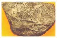
A stone tablet from Zambales Mountains found in 1985 shows the location of the lost island of Atlantis . The lines on the artifact when plotted in a world stress map being developed by USGS falls along the compression zone (causing mountains) and spreading centers (creating rifts and basins) around the globe thereby giving impression that these lines represents the “force” that reshapes the surface of the earth and creating geological stresses around the entire planet.
It's a rock.
With lines.
Looks like a cool paperweight to me...
Oh and another thing, they have hi-res pictures of the seminar but no hi-res pictures of the rock.
Ummm... does this mean that Atlantis is near the Philippines or something?